Canyon · Ablanque
Los Artesones valley (Ablanque): pine woods and sandstone along the Ablanquejo
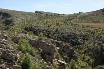
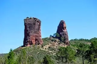
Los Artesones valley is a gorge along the Ablanquejo river near Ablanque, among pine woods and red sandstone. A circular walk of around 9 kilometres starts at Fuente del Cura recreation area. Its name comes from two troughs or basins cut into the stone which, according to local residents, were used to store ice or, during the war, weapons.
Rivers and basins
The thread of water from Los Artesones valley (Ablanque): pine woods and sandstone along the Ablanquejo
Follow these watercourses towards their confluences, villages, and basin history.
Lands and landscapes
From here, follow the memory of the territory
These readings connect Los Artesones valley (Ablanque): pine woods and sandstone along the Ablanquejo with the history, work, and villages around it.
- Municipality
- Ablanque
- Province
- Guadalajara
- Altitude
- 1,146 m
- Ablanquejo river
- Red sandstone
- 9 km circular walk
- Fuente del Cura
A sandstone gorge
Upstream from Ablanque, the Ablanquejo river, called Arroyo del Ceño further up, enters a valley of red sandstones carved by wind and rain, among pine forests and green meadows.
Why Artesones
In the valley there are two stone basins (artesas) or troughs hollowed into the rock. Ablanque locals recount that they were used to store ice and, during the Spanish Civil War, to hide weapons. No one has fully confirmed it, and that is part of its charm.
The route
A circular route of about 9 kilometres, simple though with some slopes, departs from the Fuente del Cura recreational area, beside the village. It can be combined with the hoz del Ablanquejo and the chozones de Ablanque.
Location
● Reference point · ● Villages · ● Places
Location diagram. Detailed map with tracks and names loads on zoom.
Reference villages: Ablanque · Ciruelos del Pinar · Anquela del Ducado · Mazarete.
Open the full map and historical layers →