Archaeological site · Checa
Castro de Los Castillarejos (Checa): rock-cut ditch and cyclopean tower
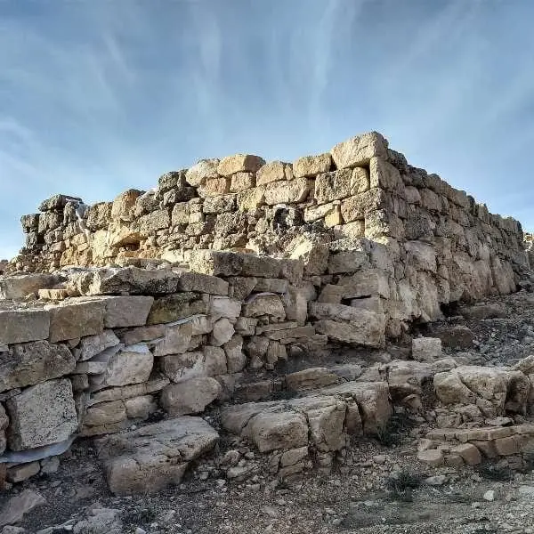
Los Castillarejos is a 2nd-century BC Celtiberian hillfort on a promontory in El Cubillo valley, south of Checa, contemporary with nearby Castil-Griegos but smaller. It preserves a large rock-cut ditch on its west and south flanks, limestone walls, and a cyclopean tower, remaining unexcavated. An early medieval hamlet later occupied its slopes.
Lands and landscapes
From here, follow the memory of the territory
These readings connect Castro de Los Castillarejos (Checa): rock-cut ditch and cyclopean tower with the history, work, and villages around it.
This place across time
Which eras you can read here
A single place can preserve traces from different eras. These layers connect what you see with the stories in the atlas.
- Municipality
- Checa
- Province
- Guadalajara
- Altitude
- 1,569 m
- 2nd century BC
- Rock-cut ditch
- Cyclopean tower
- Unexcavated
In the El Cubillo valley
South of Checa, within the El Cubillo valley, an elevated promontory preserves a second Celtiberian settlement, Los Castillarejos. It dates to the 2nd century BC, contemporaneous with Castil-Griegos, though smaller in area. The valley is the same corridor followed by Georuta 8 toward Cueva del Tornero and the Cubillo polje.
Defensive features
- A substantial defensive ditch excavated into the bedrock along the western and southern flanks.
- A walled perimeter incorporating large limestone blocks, now collapsed, where courses of cyclopean stonework remain discernible.
- A cyclopean tower base within the defensive perimeter.
The hillfort remains unexcavated. Along the slopes descending to the valley floor lie the structural remains of an early medieval hamlet, exhibiting stone door jambs, hearths, and extensive iron slag, reflecting substantial metallurgical activity.
The burials of Checa
Adjacent to the river, the Puente de la Sierra necropolis contained approximately 250 burials spanning the 5th to 2nd centuries BC, yielding pectoral discs, fibulae, belts, and domestic grave goods. Read more in the Celtiberians of the Alto Tajo.
Visiting
A clear distinction must be made: among all the Celtiberian hillforts in the Señorío, only two are genuinely prepared for visitors, El Ceremeño in Herrería and Peña Moñuz in Olmeda de Cobeta. Los Castillarejos has received little conditioning for the public: it is unadapted, virtually unsignposted, and what remains visible on the surface is very difficult to interpret without specialist guidance. If you visit, stay on the paths, do not climb on the walls, and do not remove anything from the ground.
Location
● Reference point · ● Villages · ● Places
Location diagram. Detailed map with tracks and names loads on zoom.
Reference villages: Checa · Chequilla · Orea · Peralejos de las Truchas.
Open the full map and historical layers →