Ethnography · Peralejos de las Truchas
Puente del Martinete: the first major bridge over the Tagus
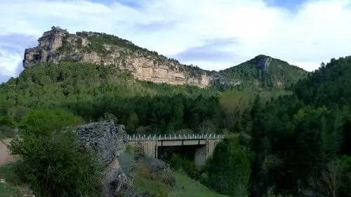
The Martinete bridge is at km 86 of the CM-2106 in Peralejos de las Truchas, right on the border between Guadalajara and Cuenca. For travellers arriving from Cuenca, it is the first true bridge over a now-flowing Tagus, after the Hoz Seca has delivered its waters a short distance upstream.
Rivers and basins
The thread of water from Puente del Martinete: the first major bridge over the Tagus
Follow these watercourses towards their confluences, villages, and basin history.
Lands and landscapes
From here, follow the memory of the territory
These readings connect Puente del Martinete: the first major bridge over the Tagus with the history, work, and villages around it.
This place across time
Which eras you can read here
A single place can preserve traces from different eras. These layers connect what you see with the stories in the atlas.
- Municipality
- Peralejos de las Truchas
- Province
- Guadalajara
- Altitude
- 1,155 m
- Guadalajara-Cuenca border
- CM-2106
- Below Hoz Seca confluence
A Tagus that is now a real river
Upstream, the cold, powerful Hoz Seca has emptied all its volume into the Tagus. By the time it reaches El Martinete, the river is already flowing strong. For anyone driving from Cuenca along the CM-2106, this is the first substantial bridge over the Tagus.
The name
It recalls the historic martinetes, the heavy water-powered trip hammers of old ironworks such as the nearby Herrería de los Morencos. It sits right on the provincial boundary, in Peralejos.
Location
● Reference point · ● Villages · ● Places
Location diagram. Detailed map with tracks and names loads on zoom.
Reference villages: Peralejos de las Truchas · Masegosa · Cueva del Hierro · Poveda de la Sierra.
Open the full map and historical layers →